선박모니터링 시스템
해상에서 운항 중인 선박의 위치 및 상태 정보를 육상관제 센터에서 실시간으로 모니터링하고 관리하는 시스템으로
사고 예방, 항로 안전 확보, 해양 환경 보호 등의 중요한 역할을 하며, 특히 자율운항선박의 안전한 운항과 원격 관리에도 필수적인 기반 인프라로 활용
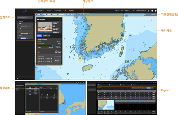
선박 위치 모니터링
- 선박 항적 수집 및 처리
- 항로 계획
기상 정보 수집 및 애니메이션 전시
- NOAA 데이터 수집
- 풍향/풍속, 유향/유속, 파향/파주기, 기온, 수온 애니메이션
웹 GIS
- 전자해도 타일맵 실시간 생성 및 관리
- 전자해도(S-57)객체 검색 및 활용 기술
WEB Service & DB
- java, javascript, SQL
선내 디지털 통신 표준 지원
- IEC-61162-1/2
선박탄소배출량 모니터링 시스템
선박 운항 중 발생하는 탄소 및 온실가스 배출량을 실시간으로 측정, 수집, 분석하는 시스템으로 선박에 장착된 연료 사용량 측정 장치, GPS 등의 위치 정보, 기상 데이터 등을
통합하여 배출량을 자동으로 계산, 수집된 데이터는 국내 외 규제 준수와 선박 효율 개선을 위한 신뢰성 있는 보고 자료로 활용
지원 표준 프로토콜NMEA 2000, Modbus, CAN-Bus
해상과 육상 간 실시간 데이터 전송VSAT, LTE, RF
AIS/GPS/항법 데이터 통합
연료 유형별 배출 계수(EF) 적용
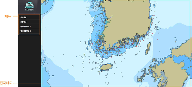
전자해도 표시 모듈
- 전자해도 도출
- 타일맵 관리
- 타일맵 생성
자선 정보 관리 모듈
- GPS 위치, 침로, 속력, 풍향/풍속
- Continuity Play
- Sersor 화면
- 선박제원
부가 정보
- 탄소 배출량
- 레이다 영상정보
- Overlay
- CAT-240
전자해도 Object 관리 모듈
- Object DB
- Object 탐색
-
영역, 지점, 탐색
(위험물/속성 기반 탐색)
타겟 정보
- AIS
- ARPA
- V-PASS
- LTE-M
도구
- 작도 도구
- 거리 측정 도구
기상 정보 전시 모듈
- 풍향/풍속
- 유향/유속
- 자항/파고/파주기
- 기온
- 수온
Vessel Monitoring System
A system that allows shore-based control centers to monitor and manage the position and status of vessels in real time during maritime operations.
It plays a critical role in accident prevention, ensuring navigational safety, and protecting the marine environment, and serves as essential infrastructure for the safe operation and remote management of autonomous vessels.
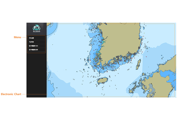
Vessel Position Monitoring
- Collects and processes vessel tracks
- Supports route planning
Weather Information Collection and Animated Display
- Collects NOAA data
- Animates wind direction/speed, current direction/speed, wave direction/period, air temperature, and sea temperature
Web GIS
- Real-time generation and management of electronic chart tile maps
- Search and utilization of electronic chart (S-57) objects
WEB Service & DB
- java, javascript, SQL
Supports Onboard Digital Communication Standards
- IEC-61162-1/2
Ship Carbon Emission Monitoring System
선박 운항 중 발생하는 탄소 및 온실가스 배출량을 실시간으로 측정, 수집, 분석하는 시스템으로 선박에 장착된 연료 사용량 측정 장치, GPS 등의 위치 정보, 기상 데이터 등을
통합하여 배출량을 자동으로 계산, 수집된 데이터는 국내 외 규제 준수와 선박 효율 개선을 위한 신뢰성 있는 보고 자료로 활용
Supported Standard Protocols: NMEA 2000, Modbus, CAN-Bus
Real-Time Data Transmission between Sea and Shore
Integration of AIS, GPS, and Navigation Data
Applies Emission Factors (EF) by Fuel Type
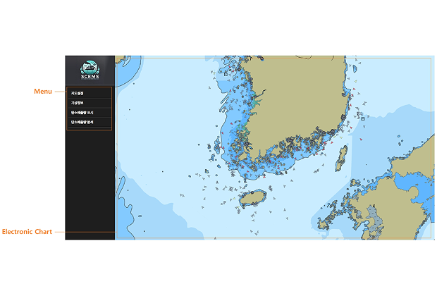
Electronic Chart Display Module
- Electronic Chart Extraction
- Tile Map Management
- Tile Map Generation
Own Ship Information Management Module
- GPS Position, Course, Speed, Wind Direction / Wind Speed
- Continuity Play
- Sensor Display Screen
- Vessel Specifications
Additional Information
- Carbon Emissions
- Radar Image Data
- Overlay
- CAT-240
Electronic Chart Object Management Module
- Object DB
- Object Search
-
Area, Point, and Route Search
(Hazard / Attribute-Based Search)
Target Information
- AIS
- ARPA
- V-PASS
- LTE-M
Tools
- Drawing Tool
- Distance Measurement Tool
Weather Information Display Module
- Wind Direction / Wind Speed
- Current Direction / Current Speed
- Wave Direction / Wave Height / Wave Period
- Air Temperature
- Sea Temperature